ArcGIS Data Source Connector
Our platform enables you to easily retrieve data from ArcGIS on a timed refresh.
After adding and authenticating an ArcGIS connection, an ArcGIS Data Source Connector can be added to a data source to pull data in from ArcGIS on a regular basis. Your data source will be automatically updated in this way until the Connector or Connection is removed.
Adding an ArcGIS Data Source Connector
Data Source Settings
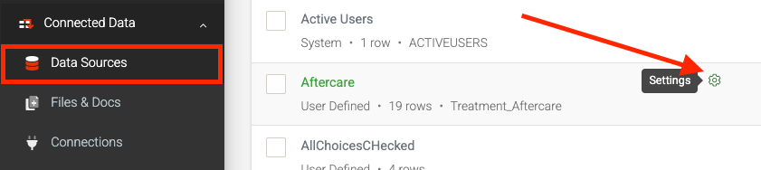
- Navigate using the left-side menu to Connected Data > Data Sources
- Hover over a form and click the “Settings” icon link
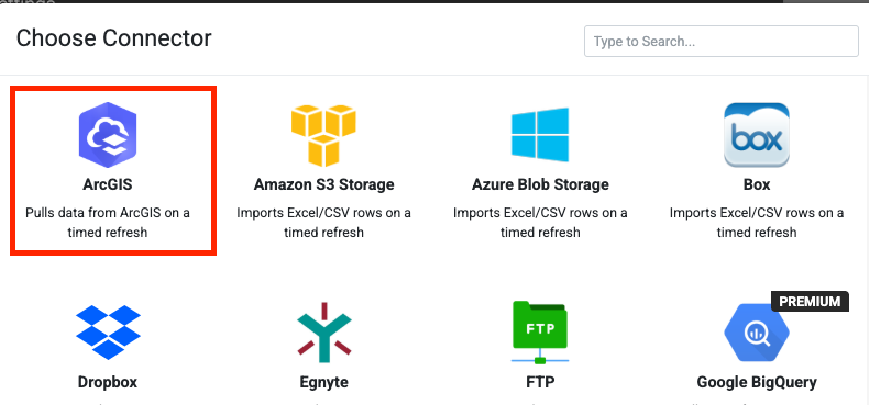
- In Settings, hit the “Add Connector” button
- Select ArcGIS
Configuring
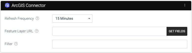
After adding the Data Source Connector, configure the connector. The configured connector requires you to add a Feature Layer URL, as shown in the screenshot below:
Refresh Frequency
The time interval at which data is pulled and refreshed by this connector.
Using Connection
Select from any of the ArcGIS connections you’ve configured more than one ArcGIS connection.
Feature Layer URL
This is where you enter the feature layer URL to which you would like to send data. Checkout our ArcGIS Form Connector article for instructions on how to find the Feature Layer URL that you will need to use here.
Filter
Add an optional filter clause to the query that only returns the desired records.
Once you’ve entered the Feature Layer URL, click the “Get Fields” button to retrieve the fields associated with this feature layer.
Once your fields have been successfully retrieved from ArcGIS, you will be able to map all the fields you’d like to be synchronized into this data source from ArcGIS by selecting each field from the “Select a field” dropdown.
Connector Logs
When you save your changes, the connector will be fired for the first time, and after that, it will run at the refresh frequency you specified in the connector settings.
Wait a minute or so, or click the three-dot menu ( ) and access the RUN NOW to manually trigger the connector and check the Rows in your data source.
If the rows were not downloaded, there may be an error with the file’s data or permissions to access it. To identify and resolve the issue, you can review the logs by clicking the three-dot menu ( ) and selecting VIEW LOGS.
Once resolved, you can rerun the connector and confirm that the rows have been successfully downloaded.
Related Articles
Data Source Connector – ArcGIS
Our platform lets you easily pull data from ArcGIS on a timed refresh. After adding and authenticating an ArcGIS connection, an ArcGIS Data Source Connector can be added to a data source to pull data in from ArcGIS on a regular basis. Your data ...Form Connector – MySQL
After adding and authenticating a MySQL Connection, you can add Data Source Connectors to pull data from a database or push data on form submissions using Form Connectors, which is what this article is about. Our platform lets you quickly and easily ...Form Connector – REST
This Connector will be interesting if you have access to technical personnel (software developers) and want to tightly integrate with our platform. The REST Connector will automatically send form entry data in XML or JSON format to your specific web ...Form Connector – ArcGIS
After adding and authenticating an ArcGIS Connection, you can easily send form entry data to the ArcGIS API by configuring the ArcGIS form connector, as shown in this article. Adding the Connector Follow these steps to add the connector to your ...Connecting to ArcGIS
ArcGIS is a Geographic Information System (GIS) software developed by Esri (Environmental Systems Research Institute). It is used for mapping, spatial analysis, and data visualization to help users understand geographic relationships and patterns. ...